Indoor mapping is exactly not a new idea; I mean, Google has over indoor maps for 10,000 locations, including many museums, all around the world. But what if you could create those maps without any hardware or installation, but instead use naturally occuring magnetic fields inside buildings to create them? That is the idea behind IndoorAtlas, a company that is pioneering this form of indoor mapping, and one that just raised its first money.
The Finland-based IndoorAtlas raised a €500,000 ($640,000) seed round from Mobility Ventures, it was announced Monday. What the company will do with the money is not clear at this time.
The company says that it is “the world’s first company to utilize magnetic anomalies inside buildings and smartphones to pinpoint positions indoors.”
So how does it work exactly?
Each building has its own unique magnetic field, the company says, and smartphones can sense them. These fields make accurate indoor positioning possible.
“Moving consumers from point A to point B can be a challenge in itself as GPS requires satellite line of sight and doesn’t work indoors. Indoor Atlas employs the smartphone’s built-in magnetic field sensor; magnetic signatures are collected inside buildings,” Indoor Atlas’ Founder & CEO Dr. Janne Haverinen, said in a statement.
“These signatures displayed unique patterns which Indoor Atlas analyzes resulting in an indoor navigation positioning and navigation solution that radically improves navigation capabilities in environments where GPS and Wi-Fi systems are unavailable.”
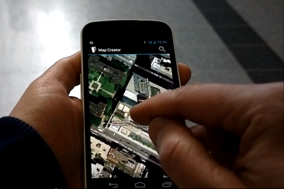
It does this by offering two tools for creating maps, allowing users to add a floor plan and then build a map based on that plan.
First, a user accesses IndoorAtlas Floor Plans, which allows them to upload their building’s floor plan to IndoorAtlas Maps. This makes it easy to align the building’s floor plan with the geographic coordinate system. Users then open the floor plan in IndoorAtlas MapCreator, which is available on Android, it order to map the floor with their smartphone. They can map part of a floor, the complete floor or even multiple floors.
Indoor Atlas also offers an API for developers to create their own apps using the technology.
Beyond just creating maps making it easier for people to get around indoors, the technology also has other practical applications, especially for businesses, including creating indoor location-awareness applications for store promotions, mobile gaming,and logistics efficiency.
“Indoor positioning is the next frontier for location-based services, offering a plethora of diverse applications and the ability of providing rich contextual information about people and objects that can prove to be very valuable when combined with ‘big data’ kinds of analytics presenting enticing advertising and branding possibilities which could revolutionize retail marketing,” Roman Kikta, Managing Partner, Mobility Ventures, said in a statement.
IndoorAtlas was founded in 2012 as a spin-off company from the University of Oulu, Finland. The company could not be reached for further comment.
Here is a short video from IndoorAtlas that explains how it works: