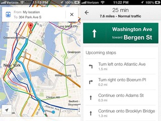
I’m sure that there are a number of reasons that people could give you for why Google Maps is simply a better app than Apple Maps. For me, the answer is simple: public transit information. The lack of bus and subway schedules on Apple Maps simply killed it for me and I downloaded the Google Maps for iOS app as soon as it became available.
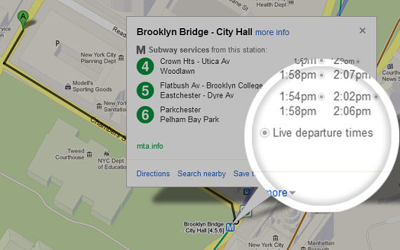
Google seems to be aware of the advantage it has in this department, as it has decided to beef up the feature, announcing Wednesday that it was debuting live departure times for transportation in New York City, Salt Lake City and Washington D.C.
Live information will be provided for seven lines on the New York City subway system, as well as the buses and trams in the greater Salt Lake City area. Riders of the Metrorail in Washington, D.C. will now get live service alerts, including unplanned delays and scheduled track work.
“With transit information in Google Maps you get pick-up locations, departure times, estimated travel time, and even fare amounts for 800 cities* across more than 25 countries around the world – that’s information for 100 million miles of daily public transit trips at your fingertips,” Soufi Esmaeilzadeh, partnership development manager for Google Maps, wrote.
The update is available for both the iOS and Android versions of the app. Google is also seeking more transit agencies to add their information to Google Maps.
This is the second update for Google Maps this month. The app for iOS was given new features that allow users to integrate the app with their contacts list and to search for nearby establishments.
The new features allowed users to sign in and have their saved addressed show up with they search for contacts in their phone, even if the addresses are not stored locally on the phone itself. A new option was also been added to the search menu that will allow the user to browse locale businesses, such as restaurants, bars, cafes, and gas stations.
Google Maps had been the default mapping application on iOS until it was dropped from iOS 6 in September. Apple instead replaced it with its own maps app called Apple Maps, which must have seemed like a good idea at the time
Unfortunately for Apple, and even more for iOS users, Apple Maps, well… it sucked. It sucked so bad that Apple CEO Tim Cook not only apologized for it, but he actually offered suggestions to iOS users about what other maps services they could use!
The reaction toward Apple Maps was so harsh that by the end of September, less a month after debuting, only 4% of iOS users were opening the app at all. And, at the time, Google Chairman, and former CEO, Eric Schmidt told reporters that Google has not submitted its own Maps app to the App Store for consideration.
All looked lost until Google surprised everyone by debuting its iOS app in December. And it turns out that people missed it to so much that the app was downloaded 10 million times in the first 48 hours it was available (you can count me as one of the 10 million).
(Image source: http://google-latlong.blogspot.com)