

April 12, 2024
Tokyo startups eye US market for expansion
Recent News

- May 21, 2024
SamaCare raises $17M to build out its prior authorization platform
The company will be expanding into other areas standing in the way of patients getting needed care

- May 20, 2024
Centivo buys Eden Health to expand its primary care plans to more employers
Eden Health connects patients to a provider team to manage their primary and mental health care

- May 17, 2024
Emi Gal, founder and CEO of Ezra, on the VatorNews podcast
Ezra offers a full-body MRI that can detect cancer and over 500 other conditions in 13 organs

- May 17, 2024
Fay emerges from stealth, raises $20M to connect people to registered dietitians
The company has partnered with insurers to make its services free to most patients

- May 16, 2024
Saint Luke's Mid America Heart Institute partners with Story Health on AFib care
Story's AFib program integrates with a health system’s clinical team to keep patients engaged

- May 15, 2024
Watershed Health raises $13.6M to tackle uncoordiated care
The company allows healthcare providers to sync up care using real-time patient information

- May 15, 2024
Survey study links prayer to improvements in well-being
Benefits of regular use of Pray.com app included spiritual, mental, and physical improvements
- May 15, 2024
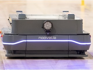
The company driving AGV/AMR technology
Noovelia's robots are flexible and vertical agnostic, automating the entire engineering process
- May 14, 2024
Flatiron Health and ACCC partner to increase access to cancer clinical trials
ACCC will use Flatiron Clinical Pipe to improve efficiency of clinical studies and research

- May 14, 2024
Talkspace rolls out teletherapy access to 13 million Medicare members
The company plans to be available to all 33 million Medicare members by the end of the year

- May 14, 2024
SmarterDx raises $50 million to fill in clinical documentation gaps with AI
The company uses its algorithm to make sure that 100% of charts are 100% accurate

- May 13, 2024
May Health raises $25M to address PCOS-related infertility
The company has developed Ovarian Rebalancing, a one-time, in-office procedure to induce ovulation

- May 10, 2024
As the US birth rate falls to record lows, which states have the highest fertility rates?
The Dakotas saw the highest number of babies per 1,000 women, while Vermont came in last
- May 9, 2024
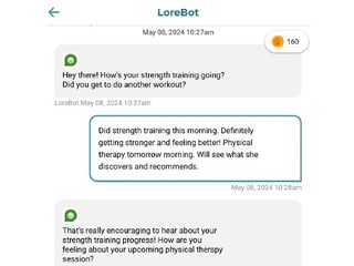
Lore Health raises $80M, launches social network using AI to cure loneliness
LoreBot asks questions and provides encouragement, while users it with provide answers
- May 9, 2024
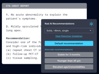
Rad AI raises $50M to invest in generative AI
The company uses machine learning and AI to make radiologists more efficient by streamlining reports
Sign up now to subscribe to our newsletter and stay up to date with the latest news!
Featured News

X to charge new users for interaction in battle against the bots
- By Anna Vod
- |
- April 25, 2024

New disease models unlocking secrets to neurological research
- By Steven Loeb
- |
- April 23, 2024
Tokyo startups eye US market for expansion
- By Kym McNicholas
- |
- April 12, 2024

Which large corporations are leading the charge in warehouse automation?
- By Steven Loeb
- |
- April 12, 2024

Healthtech investing still lags behind even as funding grew 42% in Q1
- By Steven Loeb
- |
- April 8, 2024


