You may have believed Google Eart h to already be a pretty top-notch tool for zooming in on our planet via satellite, but you’d be forgetting that much of the globe–70% actually–is completely covered by ocean.
That won’t stop Google from mapping it, though.
Over a year ago, Google launched Ocean in Google Earth 5.0, bringing 3D maps, videos, photos, and narratives about the ocean to the software. The new layer was made possible via Google partnerships with over 100 ocean institutions and organizations, including the U.S. Navy, the National Oceanographic and Atmospheric Administration (NOAA), the International Union for Conservation of Nature (IUCN), NASA, the National Geographic, and the BBC.
Google on Wednesday said that layer now is a part of the default set of annotations in Google Earth:
One of the greatest things about Earth is that it allows everyone to see and experience the fullness of their planet, from revisiting places they know well to venturing out to formerly unknown mountain peaks, desert vistas, and increasingly, the blue heart of life on Earth.
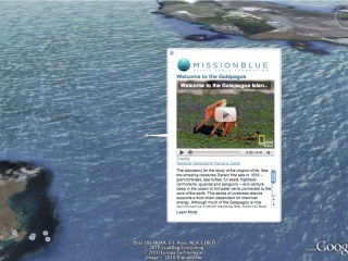
The Mission Blue Foundation has been instrumental in introducing rich ocean content to Google Earth, ever since creator Dr. Sylvia Earle asked Google Earth and Maps Director John Hanke when the software would start mapping the nearly 3/4 landless portion of our world. The Foundation seeks to open the public’s eyes to the majesty and importance of the planet’s vast waters, and bringing the oceans to Google Earth is just one step towards that goal.